Sunday, August 28, 2011

Pedestrian Perspective: A Walk to the New York State Museum

...not in a hurricane, though.  That I don't recommend.  However, if you're sitting inside bored and still have power, let's look at some pictures of a stroll on a sunny day to one of Albany's nicest places, the New York State Museum.

Lark Street, looking toward Madison Avenue.  The Belgian block intersection at Lancaster Street.
Lancaster and Lark.
Looking down Lancaster Street.  I used to live about six houses down.
Back toward Washington Avenue. The Trinity Church is on the left.
The bus going by in the picture above is a very common sight on Lark Street.  When I went to the Center Square Neighborhood Association meeting at which citizen input was solicited for the CDTA Route Restructuring project, one complaint that was mentioned was that there were too many buses on Lark.  I chalk this up to the fact that Center Square has quite a few residents who are suburbanites with a better aesthetic appreciation.  When the new system arrives there will be one fewer bus route on Lark Street, but one of the current routes becomes a "trunk" with much greater frequency and Sunday service.  Overall, Center Square is the most well-connected neighborhood to transit in the entire city, outside of downtown.

Looking at Lancaster Street again, this time toward Washington Park.
The Trinity Methodist Church.
To get to the museum from my apartment, I can take either Lancaster Street, Jay Street, Hudson Avenue, Hamilton Street or Madison Avenue.  I can take any two of them by adding Dove Street to the mix.  All of these streets are similar, but there is still a nice amount of variety among them.  That's what living in this type of environment offers: choice in your surroundings.  Really, in just two paragraphs we've seen choice in both transportation mode and favored route.  That already beats a place like Colonie, where to have your choice of route, you often sacrifice choice in transportation mode, and vice versa. 

On this trip I went with Jay Street to Dove Street to Madison Avenue.  The next time we go down this way, we'll go down to Jay below Dove, and visit the sites down there.  It's a wonderful area, and one that was almost lost to the highway.


Looking toward Lark on Jay Street.  There is a corner store here with an art gallery above.
Looking in the other direction down Jay Street.  A blurry picture but the buildings are nice at least.
Jay Street.
Concrete, brick and Belgian blocks make this a very interesting visual, just in the street itself.
You really can have off-street parking and not make it obnoxious.  It's just that most people choose not to do so.
A close-up of non-obnoxious parking.
New construction.
Jay Street is the location of one of the few infill projects in Albany.  It's a set of five townhomes that include off-street parking (underneath the buildings) and get rid of a vacant lot.  They were listed in the low $300,000's.  All of them have sold.

Thursday, August 25, 2011

Pedestrian Perspective: Lunch Break in Center Square

Yesterday, I left campus for my lunch break and went home, something I rarely do.  After stopping at the bank in the One Commerce Plaza building, I took a stroll home, then grabbed the bus back uptown a bit later.

One Commerce Plaza is the big ugly building in this picture.  The original marble cladding was replaced a few years ago because it was too heavy for exterior material.  During the renovation, a chunk of marble fell off and injured three people, a la the windows of the John Hancock Tower in Boston.  Well done, modernism...
Today's route. Bank; home; bus.
Even though it's a short walk from the bank to my apartment, there was an unusual amount of interesting (to me at least, and probably you if you're here) stuff going on.  Center Square is beautiful, but for the most part, and especially during the day, it's rather uneventful outside of Lark Street and Washington Park.  The only real excitement going on this summer is rather high amount of renovations.

New sidewalks going in along Dove Street, a street we've visited.  I think I even took a picture of this very building.
I've noticed more sidewalks being replaced this year than in years past.  Maybe they just happen to coincide with places I see.  Either way, it's a nice sight.

To get to Lark, we'll go up Chestnut, the streetscape of which I did not take a picture of.  This post is  impromptu and included no foresight whatsoever.

Always sad to see this kind of stuff in the area.  However, it never accumulates.  The Broken Windows Theory doesn't have a chance to take hold here.
It's always sad to see trash laying around the area, as it is anywhere.  It's particularly striking in Center Square, an emphatically urban neighborhood that contains regular middle-class people and gorgeous architecture.  You first expect it to be a dump, like so many inner city neighborhoods sadly are (though I will always place the blame on highways and suburbs rather than anything in the city itself).  When it's realized to be so beautiful, the reaction is unexpected.  And then garbage adds a cruel twist to the whole thing.

You can't really see the height difference in the two slabs of concrete, but trust me, I tripped on this.
The slab I tripped on is probably only raised about an inch, but large enough to almost topple a fully grown and incredibly clumsy adult male.  This is why sidewalk replacement is such a nice sight.

Saturday, August 20, 2011

One Small Step for BusPlus...

Giant leaps still pending.

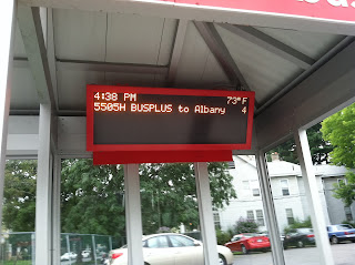
The next feature of CDTA's BusPlus service is beginning to appear, the promised real-time displays featuring the amount of time until the next arrival, as well as information such as the bus number and a time/temperature display:


And there it is.  I noticed this last weekend on my way home from the co-op and snapped these pictures.  (Posts have been slow lately as I've had very little time to work on this blog.)  I noticed another at the West Mall Station (Hannaford Plaza on Central Ave.) a couple days later coming home from the gym.

Due.
 About 10 seconds after the sign said "Due", this happened:


BusPlus is rarely late.  Thursday night, on my way to Schenectady to see West Side Story at Proctor's Theater, was one of the first times I experienced that.  During rush hour, I was waiting at North Allen Station, which did not have a real-time display, so I still don't know what happens when the sign says "due" and the bus hasn't arrived.  (I want it to say "Late" and then "Really Late" and then maybe give the number for Yellow Cab.) Additionally, there was a person in a wheelchair on the bus, which always causes (necessary and automatically forgiven) delays.  Well, to be fair, the other passengers were a bit perplexed this one time a few months ago, when a person in a motorized wheelchair was having trouble backing into the space, and instead, got out of the chair and lifted the front end of it so that it was better aligned.

Other small steps that are planned for the current iteration of BusPlus include queue jumpers and electronic communication between buses and traffic lights, which will help mitigate these issues.  The former will give the bus itself a green light before any of the other lanes of traffic get one.  The latter will allow green lights to stay lit a bit longer if a bus is running late.  You can read more about these in a Getting There post on the Times Union Blogs, including a couple of comments, the second of which is by me. 

Now for the giant leaps: 

Saturday, August 13, 2011

Unusual Riders on an Early Bus

CDTA's website had an endearing story last week from YNN (Your News Now), our local Cable TV news station, about the various professionals throughout the city that use the bus as a way to make their rounds.  They spoke of two professions that I've noticed often on the buses: parking enforcement offers and postal workers, as well as a third that I see less frequently, police officers.  (I always thought the parking enforcement offers sent the best message by ticketing cars, then getting on a bus.) 

Screen still from a YNN story, showing a bikeable officer on a bikeable bus.
I just hope these folks made it to their bus on time.

Not that it always matters.  Sometimes the buses don't give you a chance.

This happened to me last night when I left work.

The bus was supposed to get to North Allen Street, about 3 minutes away from my stop, at 5:44.  Now, to you car drivers, 3 minutes doesn't seem like much, since most of you could go 100 miles in that time, the way you drive.  But in the transit world, it's pretty big.  Especially when it's 3 minutes on the early side.

See?
Now, I'll admit that I'm notorious for getting to the stop AS THE BUS IS GETTING THERE TOO.  I am what you might call an idiot.  You can often find me on weekdays running down the street screaming like a crazy person (because clearly I'm not one) to make it on time.

So when the bus doesn't even give me that opportunity, I'm not happy.

Let's picture the scene, shall we? 

I leave work and round the corner to Western Avenue.  It's 5:44.  The bus is just getting to North Allen Street.  Right?

This is what I should see.  Instead, picture a bus in the road.  My bus.


Wait, my bus?  What? Why's the damn bus going by?  I'm still a 45 second walk from the stop at Partridge.  I mean, I can make it there by 5:47 with quite a bit of time to spare, but here we are and there it goes.

The intersection at North Allen.  Only, you can't see it in this picture.  Because the earth is round.
The intersection at Partridge.  I'm about 2/3 of the way between North Main Avenue and Partridge Street here.  Even this can barely be seen.  It's about a 30 second to 1 minute walk.  Plenty of time to make the bus, had it not been early.
A closeup of the intersection at Partridge, where my stop is.
Now, why all the whining about this early bus?  What's the problem?  Isn't being early a good thing?

Friday, August 12, 2011

Albany News Clippings

Often I would address these in separate posts, but there has been quite a bit going on this last week.  So I thought I'd do it all in one.  In addition to these news clippings, I'd like to report that the next post will be back to having fun pictures.  You'll have to bear with a text-only one this time, though. :(

Let's get to it:

1. Last week, lawmakers in Albany passed a bill to increase fines on those who neglect to shovel their sidewalks in the winter.

Good.  Screw those people.

In all seriousness, it's a huge problem in this city.  When you see people in wheelchairs rolling down the middle of the street because some lazy homeowner can't shovel their walk, it becomes simply embarrassing. Even right next door to my apartment, the walk is left all winter long.  As I've said in an earlier post, those properties that don't shovel their walks will be featured on this blog.  I'll even wait for the 24 hour grace period to expire before I snap the photos.  Then I'll make sure to send the links to the Albany Police Department.  I think a fun winter is in order!

The response on the post from the Albany section of the Times Union Blogs site has been mixed, but, of course, heavily bent against pedestrians.  Albany, we're never going to make any progress here if attitudes like this don't change.  It's a perfectly nice city with perfectly wonderful people, but this pro-car, anti-everything else bias that we have is disturbing.

Bill sponsor Leah Golby from Pine Hills had a great quote when asked if this was an anti-homeowner arrangement:  "It snows. It needs to be shoveled. Being a homeowner, owning property, is a responsibility."

You can read the full article here.

Friday, August 5, 2011

Pedestrian Perspective: Downtown Albany, Alive at Five

Yesterday I wrote about the weekly Thursday afternoon concert series on the Hudson River, Alive at Five.  We took a walk around the Hudson Riverfront Park and down to the docks, checking out the crowds and attractive, scantily-clothed men.  And we looked at some pictures from the concert itself.  Now, let's take the walk home.

This is the route we're taking, from the pedestrian bridge over I-787 to State and Swan.  I reference quite a few streets, so it might help to open this in a new window to keep track.
The view of I-787 from the Hudson River Way.  The D&H Railroad Building, now the SUNY Administration center, is in the background.
The Hudson River Way with downtown Albany in the background.  Nice sunset!
Parking.  Too much of it.  The lower uses of the city gravitate toward the highways.
The pedestrian walkway continued into downtown.  Narrow streets can be found after you cross Broadway.


Maiden Lane.  The building on the left has been stalled in its plans for residential conversion for years.  It's too bad, especially since this is such an awesome narrow street!
Crappy, blurry picture of Maiden Lane Park.  I love pocket parks.

Thursday, August 4, 2011

Alive at Five

It's Thursday, which in Albany, or at least on Lark Street, is the new Friday.  So this might not exactly be Drunk Urban Planning, but it's certainly not sober blogging.

Tonight was the last Alive at Five of the season, featuring Ed Kowalczyk and Mission Hill, playing mostly tunes by Live.  We didn't realize how many of their tunes were hits.  Whoops.

Alive at Five is a weekly event that takes places on Thursday evenings at Albany Riverfront Park, part of the Corning Preserve along the Hudson River.  The park has been upgraded and a pedestrian bridge, the Hudson River Way (according to Wikipedia) added in 2002.  Before that, the waterfront was entirely cut off from the city by, you guessed it, a highway.  I-787 to be exact.  If it's raining, the concerts are held underneath this highway at the northern end of the park. 

Ew! At least it gets better once you get to the other side.  Btw, this was taken on the way back near dusk.  The trip home will be featured in another post.

But the park itself is a really nice asset for the city.  The Corning Preserve goes between downtown Albany and Watervliet before continuing to Troy on Rt. 32 and ... some other way and Buffalo in the other direction.  It passes by streams, meadows, remnants of old piers, a barge that sells delicious food and spirits, a railroad bridge that spins to allow boats through and of course, lots and lots of chipmunks and squirrels.  There are the unfortunate aspects as well: you spend much of the time next to a highway and pass under the I-90 bridge.  However, if you forget what it represents, it's a pretty awesome sight from underneath.  Much better than the site of the rain date for the concerts.

Walkway along the river.

Looking north along the walkway.


The path to the docks.


When good environments for humans are created, attractive people just take their clothes off.

Albany's Highway System, Part One: The History

We've talked some about the South Mall Arterial, as well as I-787, which runs north-south along the Hudson River.  I-787 connects to I-90 north of Albany, which continues east to Boston and west to Chicago.  I-90 connects to I-87, which runs from New York City to Montreal.  Along the way, I-90 connects with NY-85, which continues south to Slingerlands.

Confused?

Sorry.

Here are a couple of maps:


Originally, there were even more highways planned.  The South Mall Arterial was to extend beyond Empire State Plaza to meet up with a clover-leaf interchange underneath Washington Park and connect with the Mid-Crosstown Arterial.

Seriously, the ridiculous list that I started this post with, the futuristic nightmare of the Plaza and the removal of entire districts from Albany to build the Plaza weren't enough?  We were supposed to be at that horrific level of space age?  No thanks.

Oh, yeah, I forgot to mention, the construction of Empire State Plaza and the accompanying highway system literally removed everything in the city from Swan Street to the Hudson River, bounded on the north by Washington and Howard Streets and on the south by Madison Avenue.  It could take up the area of the currently built downtown.  And if you only included actual buildings and not wasted space like parking, you could probably fit 2-3 downtowns in this area.  As part of this series, we're visiting.

Old painting of Albany, looking at the New York State Capitol and City Hall from the south.

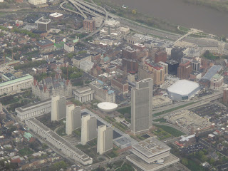
Recent aerial view of Albany.  The Plaza replaced almost everything in the picture above it.
 Let's take a look at a map of the originally proposed system:

The Hudson River is on the bottom of this map.  At the top is the Mid-Crosstown Arterial, and its connection under Washington Park.  Note the destruction of my neighborhood. (Capital Highways)
A rendering of the planned system.  See that thing in between Empire State Plaza and the park, where that highway is?  That's called Center Square, one of the Capital District's most desirable neighborhoods. (All Over Albany)