Confused?
Sorry.
Here are a couple of maps:

Originally, there were even more highways planned. The South Mall Arterial was to extend beyond Empire State Plaza to meet up with a clover-leaf interchange underneath Washington Park and connect with the Mid-Crosstown Arterial.
Seriously, the ridiculous list that I started this post with, the futuristic nightmare of the Plaza and the removal of entire districts from Albany to build the Plaza weren't enough? We were supposed to be at that horrific level of space age? No thanks.
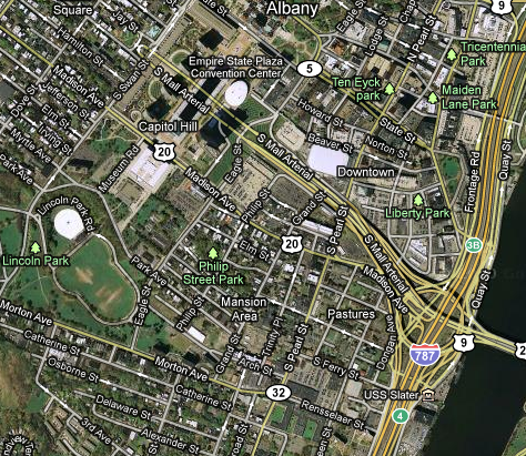
Oh, yeah, I forgot to mention, the construction of Empire State Plaza and the accompanying highway system literally removed everything in the city from Swan Street to the Hudson River, bounded on the north by Washington and Howard Streets and on the south by Madison Avenue. It could take up the area of the currently built downtown. And if you only included actual buildings and not wasted space like parking, you could probably fit 2-3 downtowns in this area. As part of this series, we're visiting.
 |
| Old painting of Albany, looking at the New York State Capitol and City Hall from the south. |
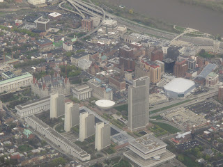 |
| Recent aerial view of Albany. The Plaza replaced almost everything in the picture above it. |
 |
| The Hudson River is on the bottom of this map. At the top is the Mid-Crosstown Arterial, and its connection under Washington Park. Note the destruction of my neighborhood. (Capital Highways) |
 |
| A rendering of the planned system. See that thing in between Empire State Plaza and the park, where that highway is? That's called Center Square, one of the Capital District's most desirable neighborhoods. (All Over Albany) |
Before the interchange under Washington Park (and by the way, seriously?) the highway would be a sunken 4-laner, much like Rt. 85 near the Harriman State Office Campus. In addition to the parking lot district, in the rest of this series, I will visit the places that would have been
 |
| NY-85 near the Harriman Campus. (Capital Highways) |
 |
| Again, like in the map above, the Hudson River is on the bottom. This mercifully rejected plan would have required the destruction of Willett Street. Just wait until we visit that one. Even worse, this wasn't a sunken highway, this was elevated. (Capital Highways) |
 |
| This map, aligned closer to the compass than the previous one, shows the Mid-Crosstown Arterial running north-south and the South Mall Arterial connecting to it. Also shown is the South Mall Expressway, which was to run through Rensselaer to I-90. (All Over Albany) |
 |
| A closeup of the "impoved" Washington Park and underground interchange (outlined). (All Over Albany) |
1. Empire State Plaza: The interchange for this, in downtown Albany, is far beyond overbuilt. It is the site of the South Mall Arterial (the South Mall was another name for Empire State Plaza), the closure of which we've discussed in a previous post. The arterial ends abruptly at Swan Street, and turns around to return to I-787. This is a direct result of the cancellation of the Mid-Crosstown Arterial, which would have met the highway further west in Washington Park. Instead, today there are two empty holes through Empire State Plaza. They'd be a perfect spot for a rail line.
 |
| The green space between the highways is where the South Mall Arterial was to continue. (Google) |
3. On the other side of the Dunn Memorial Bridge, a ramp to nowhere can be found. The highway splits into entrance and exit ramps (of another overbuilt variety), while the roadway in the middle simply ends, similar to the situation at Empire State Plaza. This was meant to continue to the South Mall Expressway, another canceled part of the system, which would have connected to I-90. This was canceled after resistance sparked by the planned demolition of a historic church for the highway project. Do I detect a common theme?
 |
| The "ramp to nowhere" in Rensselaer. As sad as this looks, what a merciful cancellation! (Wikipedia) |
Of course, that was the point.
A bunch of cars zipping unfettered around the bombed-out shell of a city from which they will soon escape to the comfort of suburbia.
For the rest of us, it amounts to nothing short of a nightmare.
 |
| The Albany Skyline dominated by highways and fly-overs. In the front of the picture you can see the "ramps to nowhere" on the Rensselaer end of the Dunn Memorial Bridge. (Google) |
References
All Over Albany - "The highway that was almost buried under Washington Park" - March 8, 2011. http://alloveralbany.com/archive/2011/03/08/the-highway-that-was-almost-buried-under-washingto
Capital Highways - "Mid-Crosstown Arterial" - 1999-2006. http://www.capitalhighways.8m.com/highways/m-ca/
Looking at photos didn't prepare me for the experience of entering the city for the first time on the South Mall Arterial a couple weeks ago on the way to the Empire State Plaza. The scale of the devastation is breathtaking, as is the audacity of the whole project. The loss of the entire urban riverfront to 787 is particularly saddening. Until reading this post, though, I had no idea the plans were even more extensive -- was it community opposition or money issues that killed them in the end?
ReplyDeleteCharlie, I believe it was a mix of both. While these plans dated from 1968, the project wasn't slated to begin until the early 1970s, when of course the economic impact of domestic peak oil production, the Vietnam War, etc. were beginning to be felt. In mid 1960s, the original Penn Station was demolished, which gave rise to the historic preservation movement. Many of the areas of the city that were meant to house this expansion of the highways were among the most historic and beautiful areas of the city that were left. Thus, it seems like both finances and opposition to the project stopped its being built.
ReplyDeleteInterestingly, the Center Square Association (the neighborhood that would have been partially destroyed for the expanded the South Mall Arterial), lists this item on the Timeline portion of their website:
1964 - Through efforts of the CSA, the City established the Historic Sites Commission. The Commission's jurisdiction included all of Center Square, except for the south side of Jay Street, which was scheduled for demolition to provide a highway exit from the Empire State Plaza.
Where did you find the plans and drawings for this(notably the color drawing of the Washington Park interchange and the map of Albany showing all the planned highways)? Thanks!
ReplyDeleteJack, the color drawings came from the first link at the bottom of the post, the one from All Over Albany. The others came from the other site at Capital Highways. Much of the plans come from the 1968 publication by the NYS DOT titled "Mid-crosstown arterial : an integral component of Albany's arterial system". Unfortunately, it is held by only two organizations: The University at Albany and the Capital District Library Council. You may be able to view it at the Special Collections Department of UAlbany. In the meantime, check out the other sites. Great information!
ReplyDeleteWorldCat entry:
http://www.worldcat.org/title/mid-crosstown-arterial-an-integral-component-of-albanys-arterial-system/oclc/5021563&referer=brief_results
Thanks for the information!
ReplyDeletepost light solar
ReplyDeletesolar post lights
solar lamp post
solar light post
solar post caps
deck post lights
solar post cap light
fence post lights
fence post light caps
fence post lights outdoor
solar light post cap
deck post solar lights
solar lamp post light
solar post cap